Water conservation plans for small water systems, 2019-2024
Mission
Our mission is to provide world class water service in a sustainable, adaptive and responsible manner to our customers through reliable, cost effective systems.
Goals
- Assure quality water through reliable and highly efficient system.
- Deliver an outstanding customer service experience.
- Anticipate and adapt to changing climactic conditions while demonstrating stewardship of our environment.
- Develop innovative and sustainable solutions through research and technology.
- Ensure organizational efficiency and manage financial resources to provide maximum customer value.
- Strengthen and uphold a culture of service, excellence and accountability.
Table of contents
Implementation, evaluation & estimated saving
Plan introduction
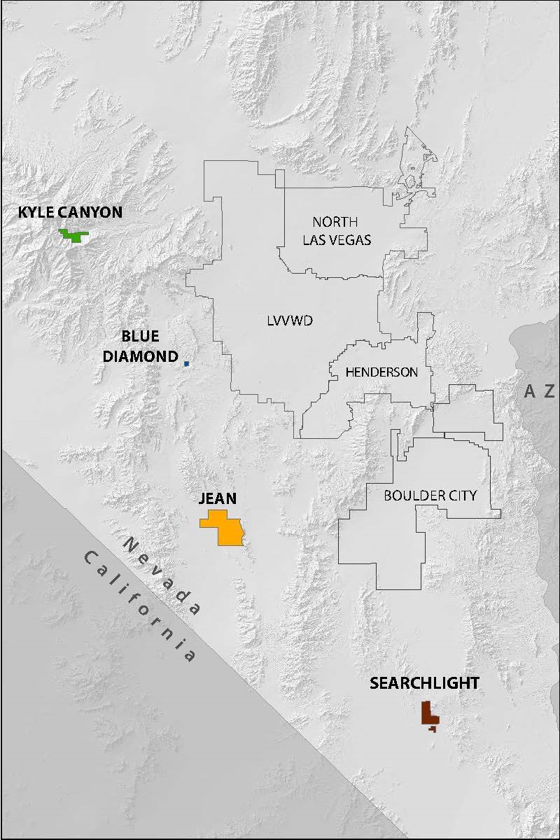
The Las Vegas Valley Water District (LVVWD) is a not-for-profit public agency that began providing water service to the Las Vegas Valley in 1954. In addition to serving residents of Las Vegas and unincorporated Clark County, the LVVWD operates several small public water systems in outlying areas of Clark County. As shown in Figure 1.1, these include water systems located in Kyle Canyon, Searchlight, Blue Diamond and Jean, Nevada.
As municipal water purveyor, the LVVWD is responsible for providing reliable, quality drinking water to its customers. This includes managing water supplies available to the community; conducting water quality treatment and testing; constructing necessary facilities; and operating and maintaining water treatment, storage and distribution facilities. LVVWD also is responsible for developing and implementing water conservation plans for the communities it serves.
The small systems described in this plan have faced several challenges over the years, from declining water levels due to changes in precipitation and recharge, to aging infrastructure and funding challenges for system improvements. The LVVWD has and will continue to work closely with its small system customers to identify system needs, address aging infrastructure, implement new technologies and improve water management through conservation efforts.
Historically, each community's ability to pursue system improvements has been constrained by limited cash reserves, insufficient revenues and/or high operational costs that must be distributed among a small population. Infrastructure improvements have been costly for many of these systems given the small number of residents with which to share the burden. As such, non-essential improvements that could enhance operational efficiency are often deferred until such time that funding is available. The LVVWD has pursued grants and loans to support the needs of these communities and will continue to seek out resources over the current planning horizon to improve small water system efficiency and operational reliability.
Conservation plan requirements
Nevada Revised Statutes (NRS) 540.121 through 540.151 requires all water suppliers in Nevada to prepare and adopt a water conservation plan based on the climate and living conditions of its service area, and to update the plan every five years. These statutes allow suppliers of water within a common geographic area to submit a joint plan. This Small Systems Water Conservation Plan (Plan) has been developed to meet these requirements and promote the efficient use of water within the four small water systems served by LVVWD.
Small systems overview
This chapter provides a brief overview of each small water system managed by LVVWD. Figure 2.1 summarizes key features by system, including LVVWD's role in system operations, the estimated population served, and water sources available to each community. Current water use (2018) and an estimate of water consumption represented by gallons per capita per day (GPCD) also is provided.
Population and water use estimates
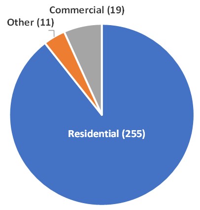
The water systems described in this plan support small communities with limited populations—most communities serve less than 500 residents and all communities have less than 500 service connections. Water use in the communities of Kyle Canyon, Searchlight and Blue Diamond is primarily residential (85 – 90 percent). In contrast, Jean has no residential customers and water is used exclusively for commercial/industrial activities.
A variety of factors influence per capita water use, including climate, demographics, building density, business or industrial water uses, and system condition/age. The latter correlates with non-revenue water loss due to system leaks, which can be difficult to locate in older systems and/or costly to repair when the burden is shared by a small customer base.
Each system's per capita water use was calculated by dividing total system water use (residential and non-residential deliveries and non-revenue water) by the estimated population served. That figure was divided by 365 to represent a daily consumption rate. Population figures used in these GPCD calculations were obtained from a 2018 Clark County Department of Comprehensive Planning report (Appendix 3) and were adjusted to include only those residents served by the small systems.
A short system profile is provided in the pages that follow for each water system. The profile includes a description of physical setting and climate; water sources and facilities; and current water uses.
| System | LVVWD Role | Estimated Population (2018) | Service Connections (2018) | Water Source | Water Usage (2018) | GPCD Usage (2018) |
|---|---|---|---|---|---|---|
| Kyle Canyon | Operator | 484 | 118 | Groundwater | 61.4 AFY | 114 |
| Searchlight | Owner/Operator | 372 | 285 | Groundwater | 221 AFY | 5321 |
| Blue Diamond | Owner/Operator | 571 | 135 | Groundwater | 102 AFY | 161 |
| Jean2 | Owner/Operator | 0 | 28 | Groundwater | 183 AFY | N/A |
1 Between 2011 and 2018 Searchlight experienced a 45 percent decrease in resident population. While GPCD has increased substantially during this timeframe, system production and accounts served have remained relatively flat.
2 Jean, Nevada has no permanent residents. As a result, it is not possible to calculate or estimate a reasonable GPCD for this water system.
Blue Diamond Water System
The LVVWD assumed operation and maintenance of the Blue Diamond Water System in 1992. As of 2018, the system serves an estimated 571 residents through 135 active accounts. The LVVWD manages the system in accordance with a 1994 Water Supply Agreement (1994 Agreement) between the LVVWD and the James Hardy Gypsum Mine (now CertainTeed Gypsum Manufacturing, Inc.), a supplier of gypsum and gypsum products. Water supply and facility arrangements detailed in the 1994 Agreement are further described below.
Physical setting and climate
Blue Diamond is approximately 15 miles southwest of Las Vegas and about 3 miles northwest of State Routes 159 and 160 (Figure 2.2). The town lies in the extreme southwestern portion of the Las Vegas Valley hydrographic basin and within the Red Rock Canyon National Conservation Area. Blue Diamond is surrounded by federal lands not currently identified for disposal, which limits the growth potential for the community. As a result, the likelihood of significant water demand increases in future years is low.
Blue Diamond experiences a desert climate with hot summers and cool winters. The average temperature ranges between 31°F to 98°F. Average summer highs range from 95°F to 98°F and frequently exceed 100°F. Average winter highs range from 54°F to 58°F. Average spring and fall temperatures are mild, ranging from 65°F to 89°F. The area is extremely dry, averaging approximately five inches of precipitation annually.
Water sources and facilities
Groundwater is the sole resource used to meet water demands for Blue Diamond. As the original water service provider for the community, CertainTeed had rights to 318 acre-feet of groundwater water annually (AFY), representing approximately 20 percent of the area's total granted groundwater rights. Of these, 150 AFY were transferred to the LVVWD under the 1994 Agreement.
As shown in Figure 2.3, Blue Diamond is served by two groundwater wells and two storage reservoirs that have a total storage capacity of 250,000 gallons. The groundwater production wells were drilled in the 1950s and are configured to provide water to both the CertainTeed manufacturing plant and the Blue Diamond public water system. The wells and booster pump that provide water to the storage tanks are owned and operated by CertainTeed. System chlorination facilities also are owned by CertainTeed, but are operated and maintained by the LVVWD to ensure compliance with Safe Drinking Water Act standards.
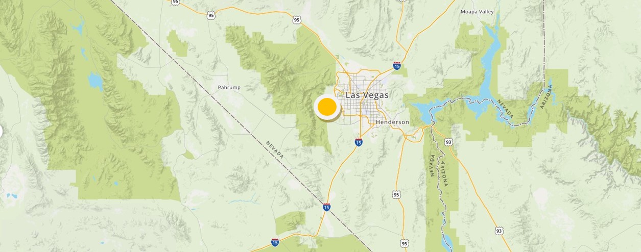
Figure 2.2
| Asset Type | Year Constructed | Pumping/Storage Capacity | Well Depth/Reservoir Elevation |
|---|---|---|---|
| BD 1 Well | ~1950 | 700 gallons per minute | 65 ft. |
| BD 2 Well | ~1950 | 400 gallons per minute | 65 ft. |
| BD Tank 1 | 1998 | 125,000 gallons | 3,509 ft. |
| BD Tank 2 | 1998 | 125,000 gallons | 3,509 ft. |
Groundwater wells recharge naturally from precipitation and snowmelt runoff in the Wilson Cliff/Red Rock Canyon and Mount Potosi areas. Annual precipitation trends correlate directly to the static water levels in the groundwater wells. Pumping and consumption by the community have a relatively small effect on local aquifer conditions. In the event of significant water level declines, municipal conservation efforts alone would not be enough to improve aquifer conditions.
Current water use
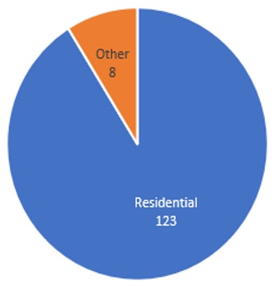
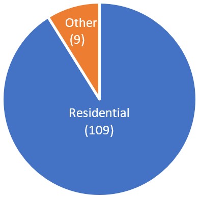
Figure 2.4 provides a GPCD estimate for the Blue Diamond water system since 2014. There is no major industry in Blue Diamond. As shown in Figure 2.5, the customer base is primarily residential.
| Year | Population Served | Estimated GPCD |
|---|---|---|
| 2014 | 545 | 183 |
| 2015 | 539 | 172 |
| 2016 | 558 | 161 |
| 2017 | 581 | 151 |
| 2018 | 571 | 161 |
Searchlight Water System
The LVVWD became responsible for the Searchlight Water System through a 1988 Interlocal agreement with Clark County and assumed full ownership of the system in 2002. As of 2018, the system serves 285 active accounts and an estimated population of 372 residents.
Physical setting and climate
Searchlight is located approximately 60 miles south of Las Vegas and approximately 40 miles north of Laughlin (Figure 2.6). The community experiences a desert climate with hot summers, mild winters and very little rainfall. The average annual temperature ranges between 36°F to 98°F. Average summer highs range from 93°F to 98°F and frequently exceed 100°F. Average winter highs range from 54°F to 59°F. Spring and fall are mild with average high temperatures ranging from 65°F to 89°F. The low temperature seldom drops below freezing and the area receives an average of 7.70 inches of precipitation annually.
Water sources and facilities
Groundwater is used to meet water demands for the Searchlight community and LVVWD has rights totaling 4,353.95 AFY in the Piute Valley and Eldorado Valley hydrologic basins. As shown in Figure 2.7, the community is served by three wells and two storage reservoirs that have a combined storage capacity of 416,000 gallons. The community also has two pressure reducing valves (PRVs). Wells S-2 and S-3 serve as community's primary production wells. Well S-1 provides additional production when needed and serves as backup for well maintenance and/or emergencies. The wells are not typically in use at the same time.
Searchlight's groundwater wells are recharged from precipitation and snowmelt runoff from the Lucy Gray Range, the Castle Mountains and the McCullough Mountains, as well as groundwater flows from the adjacent up-gradient valley.
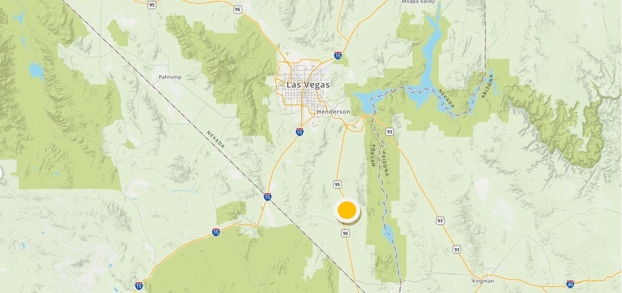
Figure 2.6
| Asset Type | Year Constructed | Pumping/Storage Capacity | Well Depth/Reservoir Elevation |
|---|---|---|---|
| S1 Well | 1983 | 240 gallons per minute | 528 ft. |
| S2 Well | 1990 | 370 gallons per minute | 900 ft. |
| S3 Well | 2009 | 380 gallons per minute | 825 ft. |
| S1 Reservoir | 1982 | 200,000 gallons | 3,709 ft. |
| S2 Reservoir | 1995 | 216,000 gallons | 3,709 ft. |
Current water use
Figure 2.8 provides a GPCD estimate for the Searchlight water system since 2014. As shown in Figure 2.9, the customer base is primarily residential. An estimated 30 to 35 percent of water used in Searchlight is non-revenue water. This is water that has been produced but is "lost" before it reaches the customer due to leaks and/or metering inaccuracies. The LVVWD's efforts to locate potential leaks within the distribution system have yielded minimal success and no significant impact to the non-revenue water rate.
The most likely cause of water loss is service line leaks, or leaks in areas of the system that cannot be detected during routine investigations. The community has been equipped with advanced metering infrastructure (AMI) with added leak detection options. This technology is being used to help LVVWD identify and address potential leaks within the water system.
Additional infrastructure upgrades are needed to help reduce non-revenue water loss and improve overall system efficiency. However, implementation of proposed improvements is dependent on the acquisition of grants or alternative funding sources to offset the cost to the community and its residents. LVVWD will continue to pursue state and federal funding sources as opportunities are identified.
| Year | Population Served | Estimated GPCD |
|---|---|---|
| 2014 | 349 | 522 |
| 2015 | 352 | 528 |
| 2016 | 362 | 501 |
| 2017 | 372 | 504 |
| 2018 | 372 | 532 |
Kyle Canyon Water System
The Kyle Canyon Water District (KCWD) was formed in 1973 as a General Improvement District pursuant to NRS 318. Clark County administers the district, but the water system has been operated and maintained by the LVVWD under contract with Clark County since 1974. As of 2018, the system serves 285 active accounts and an estimated population of 484 residents.
Physical setting and climate
As shown in Figure 2.10, Kyle Canyon is located in Clark County, approximately 35 miles northwest of downtown Las Vegas on Mount Charleston in the Toiyabe National Forest. Kyle Canyon sits approximately 6,800 feet above sea level within a heavily wooded residential area. Surrounding vegetation includes Joshua, juniper, ponderosa, bristlecone and pinon pine, and white fir trees.
The community experiences four seasons with average annual temperatures ranging between 19°F to 80°F. Average summer highs range from 80°F to 85°F, about 20 degrees cooler than the Las Vegas Valley. Spring and fall are cool with average high temperatures ranging from 50°F to 72°F. Winter temperatures are regularly below freezing, as are spring/fall lows. On average, the mountain receives 10.5 inches of precipitation annually and snow conditions are typical between November and April each year.
Water sources and facilities
Groundwater is the sole resource used to meet community water demands. The system has rights totaling just over 480 AFY. As shown in Figure 2.11, the community is served by four groundwater wells and four storage reservoirs that have a total storage capacity of 609,000 gallons. The system also includes several altitude valves and pressure reducing valves.
A variety of distribution issues have challenged the system historically, including rapid growth, well and reservoir outages, and broken lines due to freezing and age. However, the KCWD has made a number of system improvements over the years that have significantly improved system reliability, water quality and fire flow capability. For example, several of the wells have been deepened in recent years to improve reliability and in response to local drought conditions. Improvements also have reduced system loss and the KCWD has established a depreciation account to help offset the financial impacts of future infrastructure needs and replacement.
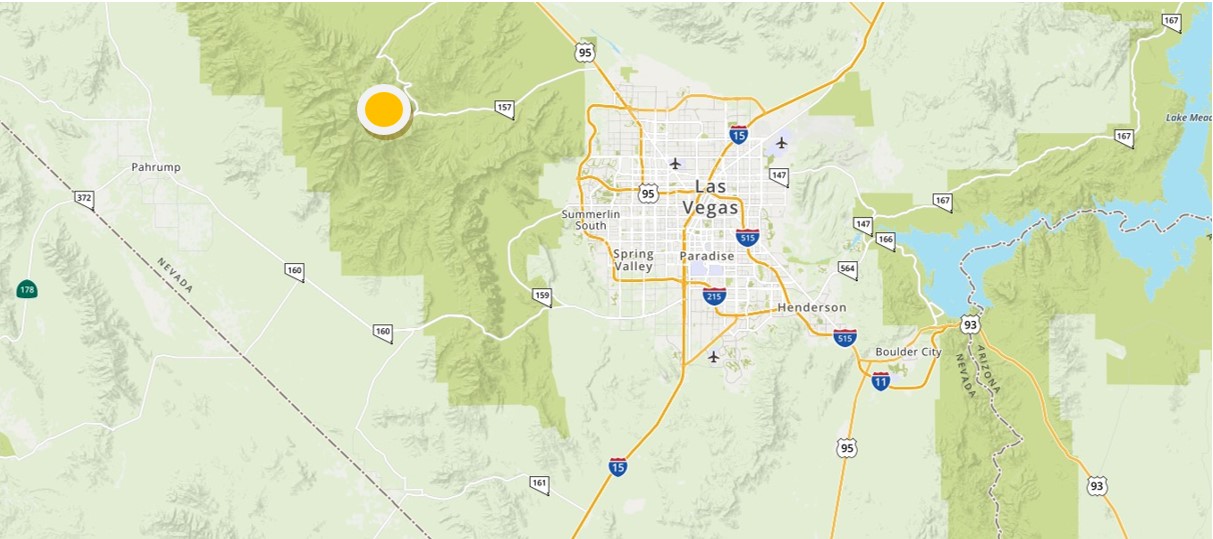
Figure 2.10
| Asset Type | Year Constructed | Pumping/Storage Capacity | Well Depth/Reservoir Elevation |
|---|---|---|---|
| Rainbow Well | 1960 | 180 gallons per minute | 286 ft. |
| Echo Well 3 | 1964 | 360 gallons per minute | 286 ft. |
| Echo Well 4 | 1997 | 180 gallons per minute | 530 ft. |
| Echo Well 5 | 2003 | 100 gallons per minute | 245 ft. |
| Echo View Reservoir | 1982 | 100,000 gallons | 7,961 ft. |
| Echo View West Reservoir | 2006 | 300,000 gallons | 7,942 ft. |
| Upper Rainbow Reservoir | 2000 | 84,000 gallons | 7,616 ft. |
| Lower Rainbow Reservoir | 2000 | 125,000 gallons | 7,503 ft. |
Current water use
Only 50 percent of homeowners in the Kyle Canyon service area are estimated to be full-time residents. This ratio fluctuates from year to year. As a result, population estimates can vary significantly from one year to the next. Some shifts in GPCD are likely to correlate to changes in the percent of full-time residents, and not necessarily changes in consumption behavior.
Likewise, water use patterns within the community can vary significantly due to local climate conditions, both seasonally and from year to year. Typically, very little outdoor water use occurs during winter months due to snow conditions and freezing temperatures. However, summer weather conditions are extremely dry and can lead to increased water use, particularly when the threat of wildfire is high.
| Year | Population Served | Estimated GPCD |
|---|---|---|
| 2014 | 474 | 115 |
| 2015 | 479 | 114 |
| 2016 | 492 | 115 |
| 2017 | 498 | 107 |
| 2018 | 484 | 114 |
Jean Water System
The LVVWD acquired the Jean water system in 1985 and is responsible for system operations and maintenance. As of 2018, there are no known permanent residents within the service area. A 2016 Clark County population estimate for the area indicates 125 residents under a category termed "group quarters." This population figure refers to the estimated population of the Jean Conservation Camp, a nearby low-security correctional facility.
Physical setting and climate
Jean is an unincorporated town administered by Clark County. As shown in Figure 2.14, the town is located approximately 30 miles south of Las Vegas and 12 miles north of the Nevada-California state line along Interstate 15.
Jean experiences a desert climate with hot summers and cool winters. The average annual temperature ranges between 34°F to 105°F. Average summer highs range from 101°F to 105°F. Average winter highs range from 57°F to 64°F. Spring and fall are warm with average high temperatures ranging from 67°F to 95°F. The low temperature seldom drops below freezing and the area receives an average of 5.8 inches of precipitation annually.
Water sources and facilities
Groundwater is the sole resource used to meet area water demands. The system has rights totaling 318 AFY. As shown in Figure 2.15, the community is served by four groundwater wells and four reservoirs with a storage capacity of two million gallons. The water distribution system includes a potable water system and a non-potable water system. A new potable well is currently under development to add additional system pumping capacity. Non-potable water is used mostly for fire protection, manufacturing activities and irrigation. If needed, potable water can be transferred to the non-potable tank.
The wells are supplied by groundwater from the Ivanpah Valley aquifer, which is recharged from the southern end of the Spring Mountains and the New York Mountains.
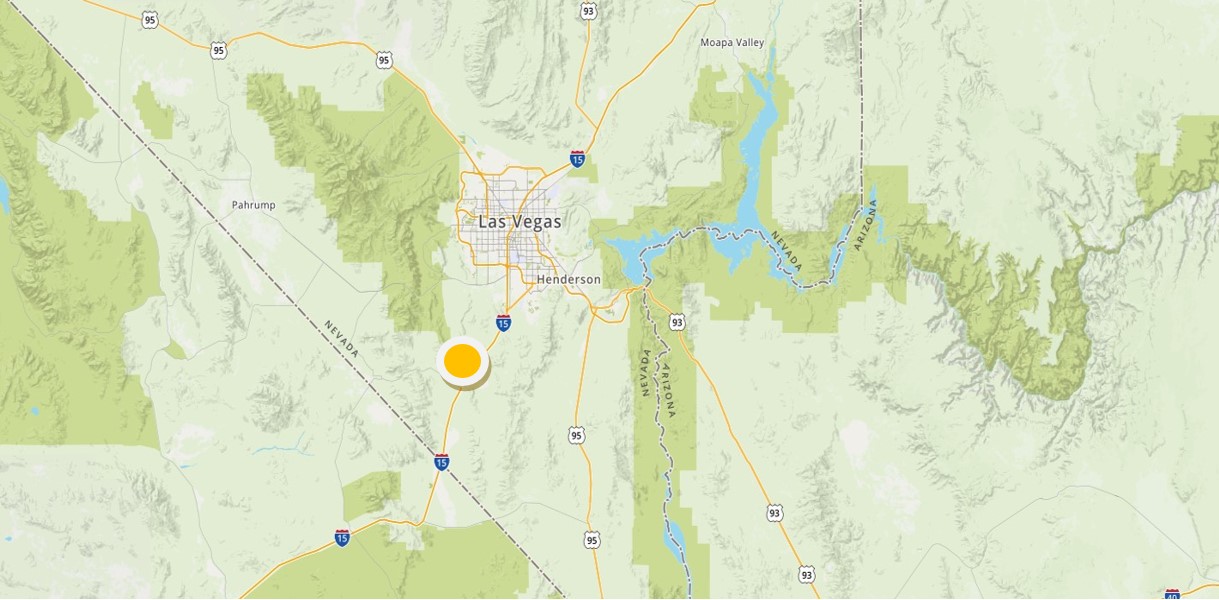
Figure 2.14
| Asset Type | Year Constructed | Pumping/Storage Capacity | Well Depth/Reservoir Elevation |
|---|---|---|---|
| State Well J2 | 1982 | 125 gallons per minute | 839 ft. |
| Goldstrike Well J3 | 1988 | 150 gallons per minute | 909 ft. |
| Midway Well J4 | 1990 | 150 gallons per minute | 820 ft. |
| Jean Well J7 (non-potable) | 2008 | 225 gallons per minute | 680 ft. |
| Reservoir I (non-potable) | 1982 | 1,000,000 gallons | 3,054 ft. |
| Reservoir II | 1982 | 400,000 gallons | 3,054 ft. |
| Reservoir IV | 2010 | 600,000 gallons | 3,054 ft. |
Current water use
Figure 2.16 provides a summary of the metered well data for 2014–2018. As previously noted and as shown in Figure 2.17, there are no permanent residents or residential water services in Jean. As a result, GPCD estimates for the community have not been calculated.
| Year | Well Production (gallons) | Population |
|---|---|---|
| 2014 | 54,710,000 | N/A |
| 2015 | 55,280,000 | N/A |
| 2016 | 54,580,000 | N/A |
| 2017 | 54,260,000 | N/A |
| 2018 | 59,880,000 | N/A |
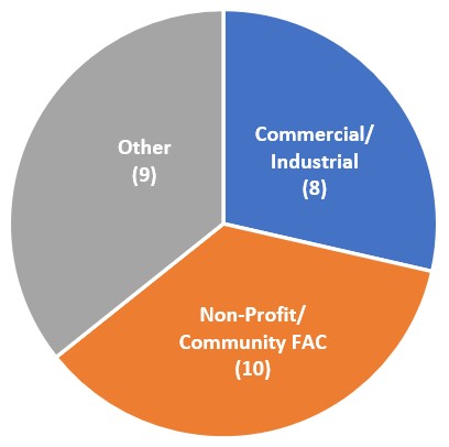
Figure 2.17
Conservation measures
This chapter describes the water management, conservation and education/outreach measures used by the LVVWD to manage available water supplies and promote the efficient use of water within the Blue Diamond, Kyle Canyon, Searchlight and Jean water systems.
Universal metering
The LVVWD meters all small system connections for all classes of water, including source-water metering. Meters are read monthly and are monitored for anomalies – such as spikes in consumption due to leaks (see also Water Loss Management and Prevention). Customer bills include a comparative water use graphic that allows customers to track and compare water use from month to month and year to year. This data helps small system customers to identify and resolve leaks sooner. Likewise, metering helps LVVWD to identify and isolate potential leaks within its distribution systems.
Meter repair and replacement
Inaccurate or non-functioning meters are repaired or replaced, and large meters are regularly maintained and calibrated.
Advanced metering infrastructure
Advanced metering infrastructure (AMI) is used within each of the small systems to help customers identify potential water leaks on their property. The technology also helps the LVVWD to quantify non-revenue water loss in the water distribution system by comparing production quantities with end user consumption.
This technology sends meter data to LVVWD via data connection for use in the billing system and other analysis. Recent meter consumption history and the data can be pulled remotely without the need to dispatch a field technician.
Incentive pricing and billing
Water rates for Kyle Canyon, Blue Diamond and Searchlight include a daily service charge plus a flat rate for water based on metered consumption. Consumption is billed in 1,000-gallon increments and the more water a customer uses, the higher the bill paid. Actual rates and fees vary by system.
The Jean water system has an increasing block rate structure with multiple thresholds for water fees, and the Kyle Canyon system has an increasing block rate for non-residential accounts. To further promote conservation, LVVWD will investigate possible implementation of increasing block rates for its other small system customers as part of future rate setting processes.
Development codes and policies
Blue Diamond, Searchlight, Jean and Kyle Canyon are subject to applicable Clark County ordinances, including:
- Chapter 24.30 - Waste of water from public water system
- Chapter 24.34 -Water use restrictions
- Title 30 - Comprehensive development code
- Title 30 -Turf limitations
Landscape watering restrictions: Landscape watering is limited to one day/week in winter, three days/week in spring and fall, and six days/week in summer. Spray irrigation is prohibited from 11 a.m. to 7 p.m. from May 1–August 30. Sunday spray irrigation is prohibited year-round.
Vehicle washing restrictions: A positive shutoff nozzle is required for residential vehicle washing. Commercial vehicle washing is prohibited unless water is captured to the sanitary sewer, where it can be treated and reused.
Turf provisions: Turf installation is prohibited in new residential front yards and is limited to a maximum of 50 percent of the landscape area in backyards. The use of turf is prohibited in new non-residential development except schools and parks.
Mist systems: Commercial use of mist systems prohibited except from May – August from 12 p.m. to 12 a.m.
Golf course water budgets: Golf Courses are subject to mandatory water budgets that allow 6.3 acre-feet of water annually per irrigated acre. New courses are limited to 45 acres per 18-hole course, plus five acres for a driving range.
Prohibitions on water waste:
- Allowing water to spray or flow off a property.
- Watering outside of assigned day(s).
- Failure to comply with landscape codes and service restrictions.
- Using sprinklers from 11 a.m. to 7 p.m. between May 1 and August 31.
- Failure to repair a malfunctioning irrigation system or supply line within 48 hours.
Failure to discharge swimming-pool/spa drainage water into a public sanitary sewer, if available.
Water efficiency standards
Plumbing fixtures in new residential or commercial buildings must incorporate state and federal standards for plumbing fixtures, including water-use standards for toilets, faucets, showerheads and urinals.
The Nevada State Legislature approved legislation in 2019 to increase water efficiency standards for new development. The new standards will become effective in 2020. Figure 3.2 includes a comparison of current and future standards for residential toilets, showerheads and bathroom faucets, as well as commercial urinals. Efficiency standards are presented in terms of gallons per minute (gpm) and/or gallons per flush (gpf). The proposed standards are expected to be implemented by summer 2020.
| Fixture/Appliance | Current Standard | 2020 Standard |
|---|---|---|
| Toilet | 1.6 gpf | 1.28 gpf |
| Urinal | 1 gpf | 0.5 gpf |
| Showerhead | 2.5 gpm | 2.0 gpm |
| Faucets | 2.2 gpm | 1.5 gpm |
Water loss management and prevention
Water loss management and prevention represent a significant opportunity to reduce water use within the small systems described in this Plan. The following section details the LVVWD efforts to reduce water loss within the distribution systems. See also "Universal Metering" and "Education and Outreach" for information about the LVVWD's efforts to inform customers about possible leaks and ways to fix them.
System maintenance
The LVVWD performs regular maintenance of its small systems to ensure operational efficiency and reduce water loss. Production wells and reservoirs are inspected to ensure their integrity; production meters are regularly maintained and calibrated; and service crews are dispatched to address significant water leaks as identified. Several of the small water systems are aging, however, and future improvements will likely be required as discussed below.
Leak monitoring & notification
LVVWD maintains water pumping records for the small systems. The records are retrieved through the Supervisory Control and Data Acquisition (SCADA) system, which provides reliable, real-time high-speed communications over a wide area. The system monitors data from various sensors and transmits real-time data back to LVVWD for analysis.
LVVWD monitors small systems daily for sudden changes in reservoir water levels or water pressure. Typically, anomalies are first investigated by comparing trends with meter data to determine if system changes are related to a customer account. In these instances, customers are notified to investigate potential problems. If meter data does not reveal a customer issue, LVVWD typically deploys portable leak detection equipment. As part of this process, LVVWD isolates pipeline sections to check for pressure drops and conducts a physical inspection to determine if there are any visible signs of leaks.
Likewise, the LVVWD generates a series of reports using meter data, including one that records constant water flow for 24 consecutive hours prior to a meter read. Residents may be alerted to investigate potential issues if their account is flagged for continuous water use.
Water system improvements
As previously noted, the greatest opportunity for water savings in Blue Diamond and Searchlight will come from improving aging infrastructure. While the LVVWD has developed plans to address and prioritize improvements, these plans are dependent upon the availability of funding. LVVWD staff will continue to monitor state and federal grant opportunities for possible funding sources for improvements, which would be too expensive for the local communities to absorb without financial assistance.
Water pressure management
Water pressure is related to the proximity of the property served to the reservoir providing service. Peak water use and routine water system operations can cause water pressure to fluctuate. Most small system water customers operate within a pressure range of 80-85 pounds per square inch (psi). In limited instances, pressure is higher or lower. When needed, pressure reducing valves (PRVs) are used to manage pressure. The LVVWD uses SCADA to monitor and adjust system pressure; conducts routine PRV calibration and dispatches distribution crews to perform repairs upon indication or observance of problems.
Controlling pressure saves water in spray irrigation by reducing the tendency for irrigation equipment to mist. It also helps save water indoors by reducing fixture flow rates and reducing flows when leaks are present.
Water reuse
Given the small and static size of the communities served and the expense of retrofit, it is not financially feasible to develop and implement water reuse systems at this time.
Incentive programs
Given current infrastructure needs and funding challenges as detailed in this Plan, there are limited opportunities available to support major incentive programs, such as a turf removal program. However, the LVVWD will work to identify state and/or federal funding opportunities to support the development of an indoor retrofit incentive program within the five-year planning horizon. If funding is available, the LVVWD will distribute low-flow aerators, low-flow showerheads and toilet flappers to small system customers. These items can significantly reduce indoor water use and extend available supplies.
Outreach and education programs
The LVVWD promotes water conservation in several ways, including education, outreach and community engagement. The following describe current outreach efforts for the LVVWD's small water systems, as well as other valley-wide resources available to small system customers.
LVVWD website
The LVVWD's website (lvvwd.com) promotes water conservation among all water users. Resources include:
- Video tutorials on how to find and fix leaks in irrigation systems, pools/spas, water softeners, main service lines and toilets.
- Video tutorials and tips for improving indoor water efficiency (installation and use of high-efficiency appliances, faucet aerators, showerheads and toilets).
- Video tutorials and tips for maintain landscapes year-round (irrigation system operations, testing/ fine tuning stations, setting/adjusting irrigation clocks, and checking/repairing watering systems).
- Cold weather tips (plant fertilization and pruning, turf care, protecting/maintaining pipes and hoses, and maintaining pools).
- Warm weather tips for dealing with common landscape challenges such as brown spots, burned or scorched leaves and compacted soils.
- Informational resources on turf care and plant selection. Visitors can browse the website for hundreds of desert-friendly plants with information on water requirements, maintenance, growth rates and photos. Other community resources include the Southern Nevada Water Authority's website (snwa.com), which offers free tips and resources that help residents save water.
Bill messages, inserts and print communications
Small system customers receive a customized bill that includes comparative information on their property's water use. Unusually high consumption could indicate the presence of a leak and customers are encouraged to look for and address potential problems. The LVVWD recently upgraded its billing system and one new feature includes the use of custom messaging on the bill header. The LVVWD will use this tool to remind customers of seasonal watering restrictions, including time-of-day watering restrictions, or to provide information on water operating conditions.
The LVVWD also will continue to utilize bill inserts to promote water efficient landscaping, compliance with watering restrictions, promote class offerings and to provide seasonal water conservation tips. Other print communications include the Water Watch newsletter. The LVVWD will continue to produce this newsletter to help educate small system residents about conservation issues and techniques.
Community engagement
The Kyle Canyon, Blue Diamond and Searchlight systems have a dedicated LVVWD community liaison. LVVWD staff will continue to attend monthly Town Advisory Board meetings to share information with the communities served related to conservation and water system operations. Liaisons provide regular updates, answer questions and coordinate more formal updates/presentations to the community when needed.
Youth education
The LVVWD's Springs Preserve is a 180-acre museum complex that includes museums, galleries, gardens and trails. The Preserve offers free self-guided field trip tours to local schools, including schools located in the small system service areas. At the Preserve, visitors can learn more about natural resource, including water resource, conservation and sustainability topics. Likewise, the LVVWD publishes Desert Discovery twice annually. The newsletter, available for grades K-2 and 3-5, features articles and activities about water conservation and resources. It is distributed free of charge to about 250 local public and private elementary schools. The newsletters are accompanied by a teacher's edition.
Conservation helpline
The SNWA operates a Conservation Helpline (702-258-SAVE) available to all Southern Nevada residents, including small system customers. The Helpline is a resource for customers to ask conservation questions, report water waste and obtain general water conservation information.
Other
Encourage drip irrigation for trees and shrubs
While trees and shrubs provide a host of benefits, they also can be a source of inefficient watering. Some small systems residents use hand-placed sprinklers or hand water to irrigate their landscapes. Drip systems are substantially more water efficient compared to sprinkler or hand irrigation. Drip systems limit the amount of water wasted and provide a deeper soak than sprinklers.
Online and print communications are used to encourage residents to use drip systems to water trees and shrubs. Residents also are encouraged to visit lvvwd.com for more information about drip irrigation or visit the Springs Preserve, which offers classes on the installation of drip systems.
Encourage the use of native or desert-adapted plants in landscape design
While many small system customers have limited turf, residents with ornamental turf are encouraged to use native and drought-tolerant plants when making landscape changes. In the Las Vegas Valley, native landscapes use approximately 55 gallons less water per square foot than traditional grass.
Drought contingency plan
For actual or anticipated water service interruptions related to drought, the LVVWD will take steps to reduce water demands by enforcing provisions within its service rules for each of the small system service areas.
- These rules allow LVVWD to reject, rescind, reduce or terminate current or proposed uses of water where such uses:
- Are contrary to the LVVWD's obligation to ensure reasonable use including, but not limited to, compliance with rules for water efficiency, drought, conservation and the use of non-potable water for irrigation.
- May encumber or impair the LVVWD's ability to maintain an adequate level of service to other customers.
- Compromise public health, welfare or safety due to circumstances that limit the available water supply to the water system.
In the event of a continued and sustained drought where water levels in system wells reach depths that pose risk to drinking water supplies, the LVVWD will focus on reducing non-essential water uses and water waste. Specific drought response efforts may include the following:
Mandatory watering restrictions
In addition to the water use restrictions defined in Clark County ordinance and described in Chapter 3, the LVVWD could implement landscape watering restrictions that would further limit or prohibit landscape watering. These measures would help to preserve system supplies for potable use and reduce operational demands on system infrastructure. If implemented, the nature and duration of these restrictions would be based on local water and system conditions.
The Kyle Canyon Water District approved a water management plan in 2003 to address declining water levels in system wells. The plan describes system operating ranges based on well levels (sustainable, concerned and critical) and prescribes additional landscape watering restrictions based on service address. Under an emergency condition, all outdoor water use is restricted.
Small system customers are subject to the water waste prohibitions as described earlier in this chapter. While the LVVWD does not actively conduct water waste investigations in its small systems due to the cost and labor associated with patrolling these remote locations, LVVWD may implement enforcement activities if local conditions warrant.
Drought surcharges
Drought surcharges are temporary pricing signals intended to encourage reductions in water consumption during drought conditions. The LVVWD could implement a drought surcharge, which could be modified as needed based on community performance in meeting water demand reduction needs to ensure a reliable potable water supply.
Notification of well operating conditions
The LVVWD will make efforts to notify customers via mail, printed fliers, bill messaging and/or other available means if or when known water operating conditions are expected to pose a risk to continued water services. Notices will include instructions for reducing water use and other relevant information.
Alternate supply
In the event of an emergency water-service interruption, the LVVWD has plans in place to provide limited-term potable water supplies until service is restored. Supply options could include bottled water and/or water truck deliveries and well deepening. Given Blue Diamond's proximity to the LVVWD service area, a temporary connection between the LVVWD and Blue Diamond Water System could be pursued for that system if necessary to ensure reliable potable water service. The location and proximity of other service areas make temporary connections cost prohibitive and too geographically complex to implement.
Implementation, evaluation & estimated savings
The following depicts new or ongoing efforts planned for implementation during the 5-year reporting period. Unless otherwise noted, these conservation measures apply to each of the small water systems described in this Plan.
| Conservation Measure | 2019 | 2020 | 2021 | 2022 | 2023 |
|---|---|---|---|---|---|
| Universal Metering | |||||
| Meter repair and replacement | x | x | x | x | x |
| Advanced meter reading (AMI) | x | x | x | x | x |
| Incentive Pricing and Billing | |||||
| Metered/consumption-based rates | x | x | x | x | x |
| Tiered rate (Jean) | x | x | x | x | x |
| Development Codes and Policies | |||||
| Landscape watering restrictions | x | x | x | x | x |
| Vehicle washing restrictions | x | x | x | x | x |
| Turf provisions | x | x | x | x | x |
| Mist systems | x | x | x | x | x |
| Water waste prohibitions | x | x | x | x | x |
| Increased Water Efficiency Standards | |||||
| Implement water efficiency standards for fixtures | x | x | x | x | |
| Water Loss Management and Operations | |||||
| System maintenance | x | x | x | x | x |
| Water pressure management | x | x | x | x | x |
| Outreach & Education Programs | |||||
| Website (lvvwd.com / snwa.com) | x | x | x | x | x |
| Online video tutorials, tips and resources | x | x | x | x | x |
| Bill messages/inserts & print communications | x | x | x | x | x |
| Community engagement | x | x | x | x | x |
| Youth education | x | x | x | x | x |
| Conservation Helpline | x | x | x | x | x |
| Other | |||||
| Water system improvements | Implement as funding allows | ||||
| Incentive programs | Implement as funding allows | ||||
| Tiered rates (Blue Diamond, Searchlight and Kyle Canyon) | Evaluate during next rate setting process | ||||
| Drought Contingency Plan | Implement as needed | ||||
Evaluation
Figure 4.2 includes an estimate of water savings by individual conservation measure. The LVVWD 's Conservation Division and Small Systems workgroup will continue to monitor infrastructure needs, system operations, community water supplies, water-use trends and conservation progress over the five-year planning horizon. Likewise, the team will determine if additional community outreach is needed to elicit additional conservation savings or if other actions may be required.
| Conservation Measure | Kyle Canyon | Blue Diamond | Searchlight | Jean |
|---|---|---|---|---|
| Universal metering | 2,120,000 gallons/year | 417,000 gallon/year | 543,000 gallon/year | 20,000 gallon/year |
| AMI infrastructure | 884,000 gallon/year | 313,000 gallon/year | 611,000 gallon/year | 10,000 gallon/year |
| Water fixtures retrofit | 530,000 gallon/year | 625,000 gallon/year | 407,000 gallon/year | 8,000 gallon/year |
| Encourage drip irrigationfor trees and shrubs | 177,000 gallon/year | 208,000 gallon/year | 136,000 gallon/year | 5,000 gallon/year |
| Encourage use of native landscaping when planning upgrades | 88,000 gallon/year | 156,000 gallon/year | 68,000 gallon/year | 3,000 gallon/year |
| Outreach & education programs | 230,000 gallon/year | 271,000 gallon/year | 177,000 gallon/year | 1,000 gallon/year |
| Leak detection and system improvements | Steel line replacements 2-3 million gallons/year |
Steel main/service line replacements 3-4 million gallons/year |
PVC and Steel main replacements 3-5 million gallons/year |
Tank repairs 2 -3 million gallons/year |
Appendix 1 – Public comment
The Las Vegas Valley Water District Small Systems Conservation Plan for Kyle Canyon, Blue Diamond, Searchlight and Jean was presented by LVVWD staff to the Mt. Charleston Town Advisory Board on 8/1/19, Red Rock Citizens Advisory Council (Blue Diamond) on 7/31/19, Searchlight Town Advisory Board on 8/14/19 and Goodsprings Citizens Advisory Council (Jean) on 7/30/19.
The draft Plan was available for public review and comment from 8/14/19 to 8/27/19 at lvvwd.com. A copy of the draft Plan was also available at the following locations for public inspection:
Mt. Charleston Library (Kyle Canyon)
75 Ski Chalet Place
Mt. Charleston, Nevada 89124
Blue Diamond Library
14 Cottonwood Drive
Blue Diamond, Nevada 89004
Searchlight Community Center
200 Micheal Way
Searchlight, Nevada 89046
Goodsprings Justice Court
23120 S. Las Vegas Boulevard
Goodsprings, Nevada 89019
Las Vegas Valley Water District
1001 S. Valley View Blvd.
Las Vegas, NV 89153
From: Evan Blythin (2)
Subject: Blue Diamond well levels that mandate water restrictions
Message: According to the LVVAD site, there are levels of the Blue Diamond wells that will trigger water restrictions. What are those levels? Thank you for your time. Evan
Message: The Small Systems Water Conservation Plan for Blue Diamond seems nicely thought out. However, the plan fails to take in consideration one of the biggest water user in Blue Diamond, the County Park. The County Park uses a high water grass that requires approximately 2 million gallons of water a year--that could be cut in half with a change to Bermuda grass. The public comment period regarding the conservation plan runs to the end of August. I would like this email to be part of the public comment. Thank you for your time.
From: Robert Matthews
Subject: small systems conservation draft
Message: Would it be possible to have discussions about sustainable, concerned and critical levels for the Blue Diamond wells? Discussions can be done at the Red Rock Citizens Advisory Council meetings. Thank You...
From: Barbara Luke
Subject: Comments for the SSWCP:
Regarding Blue Diamond, BD's allotment is not out of CertainTeed's 138, correct? The wording is ambiguous to me. It would be great for the report to state who else has allocations in the ~138*5=690 AFY.
A couple of times BD users have received (upon request?) charts that show all households' annual usage, anonymized except for the requestor. That would be a great tool to continue with – shows us where we stand with respect to our neighbors.
It's hard to know which of the water conservation rules that are broadly advertised across the LV Valley apply to us. I think we even get - or at least used to get – content that applies to most of the Valley but not to us with our monthly bills. I did not know that the landscape watering restrictions stated in the SSWCP apply in BD, even though I've been living in BD for 15 years – I thought they didn't. I guess it's just the part about designated watering days that doesn't apply to us. (Except Sunday - now I know that's everywhere.) Maybe an occasional reminder – emphasizing that it's the rules in BD – with our bill so we don't think it's only for the non-small systems users.
I (we!) appreciate having a dedicated liaison, who attends every local advisory council meeting. It seems that at our meetings we spend more time on water than on anything else.
The Springs Preserve is a great resource that seems under-utilized. Does it need better PR?
Appendix 2 – Clark County ordinances
Chapter 24.30 - Waste of water from public water system
24.30.010 - Definitions.
As used in this chapter, unless the context otherwise requires, the following words shall have the meanings ascribed to them:
(1) "Customer" means any person who is an owner, occupant, manager or user of real property to which water is supplied by a public water system, any person who uses water supplied by a public water system, any person who is billed for the supply of water from a public water system, or any person who otherwise has the right or permission to utilize water provided by a public water system, but does not include any firefighting department or agency.
(2) "Notice of violation" means a written warning which describes how water is being wasted and warns the customer that it is unlawful to waste water after service of the notice.
(3) "Public water system" means any publicly or privately owned network of pipes, conduits, wells, reservoirs, holding tanks and other components, including any combination thereof, which supplies water to customers who are charged a fee of any kind or nature for such purpose or which is designed to supply water or is capable of supplying water to customers for a fee and includes any such system whether or not it is operated under the regulatory authority of the Nevada Public Service Commission, but does not include any irrigation company or district whose primary purpose is to supply water for farming.
(4) "Service of a notice of violation" means:
(a) Personal service upon a customer;
(b) Personal service upon a person of suitable age and discretion residing at the customer's residence or working for the customer at the place where the waste of water initiates;
(c) Posting such notice upon the premises where the waste of water initiates; or
(d) Mailing a copy of such notice to the customer at his address as shown on the records of the public water system.
(5) "To waste water" means the expenditure or application of water from a public water system that results in water:
(a) Flowing into any gutter, street, sidewalk, swale or storm drain in a steady stream or flow during the course of a period of five or more continuous minutes; or
(b) Collecting in pools or any depressed area in a public street, sidewalk or right-of-way to a depth of two inches or more.
(Ord. 2934 § 3, 2003: Ord. 1213 § 1, 1990)
24.30.020 - Unlawful to waste water when.
(a) It is unlawful for any customer of a public water system to waste water in the unincorporated areas of the county after having been served a notice of violation for wasting water from the same location or premises.
(b) It is unlawful for any owner, occupant or manager of real property in the incorporated areas of the county to allow the waste of water from such property after there has been a service of a notice of violation for wasting water from the same premises.
Chapter 24.34 - Water use restrictions
24.34.010 - Definitions
For the purpose of this chapter, the following terms, phrases, words and their derivations shall have the following meanings:
(a) "Customer" refers to any person who is an owner, occupant, or user of real property to which water is supplied by a public water system. "Customer" shall also refer to any person who uses water supplied by a public water system, or to any person who is billed for the supply of water from a public water system, or to any person who is responsible for or otherwise has the right or permission to utilize the supply of water provided by a public water system.
(b) "Hand watering" refers to the use or application of water by a customer or any person through a hose connected to a piping system while such hose is hand held by an individual and such water is sporadically used for any exterior purpose or is otherwise expended outside any dwelling, building or structure.
(c) "Irrigate" means to apply or to expend water onto land whether by channels, by flooding, by sprinkling, or any other means whatsoever.
(d) "Person" means any natural person, any group of persons, any firm, partnership, association, corporation, company, or any other organization or entity.
(e) "Public water system" refers to any network of pipes, conduits, wells, machinery, reservoirs, holding tanks, and any other components, including any combination thereof, which supplies water to customers who are charged a fee of any kind or nature for such service or which is designed to supply water or is capable of supplying water to customers for a fee at two or more dwellings, buildings, structures or lots. Public water system does not include water supplied by an irrigation district for agricultural purposes.
(f) "Wastewater" means treated effluent from any sewer treatment plant operated by a governmental or private entity.
(g) "Water" refers to all water, including wastewater, supplied to any customer who uses water.
(h) "Irrigation system testing" refers to sprinkler testing done after lawn mowing to identify broken heads, and after repairs to flush lines, properly align sprinkler heads or to locate a reported leak.
(i) "Syringing" refers to a method used to cool down hot spots under visible signs of stress. This method utilizes hand-held remote irrigation controllers or computerized central controls.
(j) "Landscape irrigation audit" refers to a process used to test the application rate and efficiency of an irrigation system. Sprinkler heads are aligned and cups are placed across the turf area. The sprinklers are run and the amount of water caught in the cups is measured.
(k) "Subsurface watering system" means an irrigation watering delivery system that emits water underground directly to the plant at the root zone level.
(Ord. 1702 § 1, 1995: Ord. 1403 § 1 (part), 1992: Ord. 1271 § 1 (part), 1991)
24.34.020 - Limitation on irrigation.
From May 1st through August 31 of each calendar year from the hours of eleven a.m. until seven p.m. it is unlawful for any customer of a public water system to use water within the unincorporated areas of the county for the purpose of irrigating, regardless of method, exterior lawns, gardens, trees, grass, shrubbery, or other vegetation except as provided in Section 24.34.030.
(Ord. 2934 § 4, 2003: Ord. 1271 § 1 (part), 1991)
(Ord. No. 4515, § 1, 9-6-2017)
24.34.030 - Exceptions.
The provisions of Section 24.34.020 do not apply to:
(a) Hand watering;
(b) Irrigation of new lawns, for a period of thirty days from planting or the date of installation;
(c) Irrigation by commercial gardens, plant nurseries, retail marijuana cultivation establishments or medical marijuana cultivation facilities licensed in accordance with Title 6 or Title 8 of this code, provided the licensee or his representative are personally on the premises at the time watering is taking place;
(d) Irrigation system testing; provided, that the individual conducting the test must be present and observe sprinkler performance;
(e) Landscape irrigation audits; provided, that the auditor performing the test must be present and observe sprinkler performance;
(f) Irrigation from a low-volume drip system or subsurface watering system.
(Ord. 1702 § 2, 1995: Ord. 1403 § 1 (part), 1992: Ord. 1271 § 1 (part), 1991)
(Ord. No. 4244, § 3, 10-21-2014; Ord. No. 4486, § 3, 5-16-2017; Ord. No. 4515, § 1, 9-6-2017)
24.34.040 - Violations and penalties.
Any person violating any of the provisions of this chapter is guilty of a misdemeanor and, upon conviction thereof, shall be punished as provided in Section 1.01.040 of this code. Additionally, any person, group of persons, partnership, corporation or other business or governmental entity which is not a public utility regulated by the Public Service Commission of Nevada and which furnishes water to persons who violate the provisions of this chapter may reduce or terminate water service to such person or persons.
(Ord. 1271 § 1 (part), 1991)
Title 30.64.060.6 Landscaping (Excerpt)
j. Turf. These restrictions cannot be waived or varied.
Turf limitations apply as follows:
1. Single-family and multifamily developments are prohibited from installing new turf in common areas of residential neighborhoods. This restriction shall not apply to privately owned and maintained parks, including required open space;
2. The installation of new turf in non-residential developments is prohibited. This restriction shall not apply to schools, parks, amphitheaters, or cemeteries; to turf required by other governmental jurisdictions and/or regulatory agencies; or to golf courses and driving ranges subject to regulations listed below;
3. The installation of new turf is prohibited in residential front yards;
4. For single-family residential lots, the installation of new turf shall not exceed 50% of the gross area of the side and rear yard or 100 square feet, whichever is greater. In any case, a maximum of 5,000 square feet of turf is permitted;
5. Development within subdivisions approved after July 1, 1992 shall not impose restrictions which require the use of turf in landscaping or which prevent the use of xeriscaping as an alternative to turf;
6. The maximum slope of a turf area shall not exceed 33%;
7. Turf areas shall not be located within 6 feet of a street, curb, paved surface other than a single-family residential driveway, or sidewalk if adjacent to a paved surface;
8. No area of turf shall have a width or depth less than 10 feet. This area may be less than 10 feet wide if adjacent to a planter bed or other landscape area which will catch overspray;
9. Golf courses shall be limited to a maximum of 45 acres for 18 holes and 5 acres for a driving range;
Appendix 3 – Clark County population estimates
| Place/Community | Single Family | Duplex 3/4 -Plex |
Mobile Home | Apartments | Town-homes | Condominiums | Group Quarters | Total Population (Includes Group Quarters) |
|---|---|---|---|---|---|---|---|---|
| Clark County | 1,423,122 | 49,022 | 60,554 | 454,356 | 103,602 | 171,588 | 22,372 | 2,284,616 |
| Cities | 844,684 | 31,384 | 17,221 | 221,848 | 56,866 | 79,131 | 7,339 | 1,258,474 |
| Unincorporated Areas | 578,437 | 17,638 | 43,332 | 232,508 | 46,736 | 92,457 | 15,033 | 1,026,142 |
| Las Vegas Valley Urban Area | 1,387,892 | 48,201 | 51,644 | 447,383 | 97,456 | 164,732 | 15,303 | 2,212,610 |
| Cities | 822,474 | 30,673 | 13,886 | 219,143 | 51,911 | 74,589 | 6,828 | 1,219,505 |
| Unincorporated Areas | 565,417 | 17,528 | 37,758 | 228,239 | 45,545 | 90,142 | 8,475 | 993,105 |
| Outlying Areas | 35,230 | 821 | 8,910 | 6,973 | 6,146 | 6,856 | 7,069 | 72,006 |
| Cities | 22,210 | 711 | 3,336 | 2,705 | 4,955 | 4,542 | 511 | 38,969 |
| Unincorporated Areas | 13,020 | 110 | 5,574 | 4,268 | 1,191 | 2,315 | 6,558 | 33,036 |
| Cities | ||||||||
| Boulder City | 9,575 | 494 | 2,772 | 971 | 686 | 1,177 | 429 | 16,104 |
| Henderson | 217,917 | 1,355 | 3,581 | 53,332 | 17,836 | 19,212 | 1,253 | 314,486 |
| Las Vegas | 412,890 | 17,677 | 7,645 | 135,351 | 26,351 | 48,914 | 4,090 | 652,918 |
| Mesquite | 12,635 | 217 | 563 | 1,734 | 4,269 | 3,364 | 82 | 22,865 |
| North Las Vegas | 191,667 | 11,641 | 2,659 | 30,461 | 7,725 | 6,464 | 1,485 | 252,101 |
| Unincorporated Areas in the Las Vegas Valley | ||||||||
| Enterprise | 161,299 | 190 | 313 | 27,702 | 7,493 | 11,926 | 161 | 209,086 |
| Lone Mountain | 18,327 | 12 | 202 | 0 | 0 | 0 | 0 | 18,541 |
| Nellis AFB | 0 | 0 | 0 | 0 | 0 | 0 | 6,612 | 6,612 |
| Paradise | 81,226 | 4,194 | 5,993 | 68,805 | 13,400 | 24,664 | 992 | 199,274 |
| Sloan | 27 | 19 | 76 | 0 | 0 | 0 | 0 | 123 |
| Spring Valley | 122,743 | 2,390 | 3,733 | 53,046 | 10,657 | 34,043 | 611 | 227,222 |
| Summerlin South | 25,736 | 0 | 0 | 3,679 | 1,235 | 1,680 | 0 | 32,330 |
| Sunrise Manor | 118,078 | 9,528 | 23,356 | 48,324 | 6,114 | 10,837 | 20 | 216,258 |
| Whitney | 27,346 | 107 | 1,446 | 10,753 | 3,787 | 2,601 | 0 | 46,040 |
| Winchester | 7,077 | 1,009 | 2,528 | 15,917 | 2,859 | 4,390 | 79 | 33,858 |
| Urban "County Islands" | 3,557 | 80 | 112 | 14 | 0 | 0 | 0 | 3,763 |
| Unincorporated Outlying Areas1 | ||||||||
| Blue Diamond | 487 | 0 | 68 | 15 | 0 | 0 | 0 | 571 |
| Bunkerville | 891 | 15 | 157 | 0 | 0 | 0 | 0 | 1,064 |
| Cal-Nev-Ari | 40 | 0 | 121 | 0 | 0 | 0 | 0 | 162 |
| Corn Creek | 18 | 0 | 37 | 0 | 0 | 0 | 0 | 55 |
| Fort Mojave Reservation | 0 | 0 | 0 | 0 | 0 | 0 | 384 | 384 |
| Goodsprings | 123 | 14 | 85 | 0 | 0 | 0 | 0 | 222 |
| Indian Springs | 211 | 8 | 922 | 13 | 0 | 0 | 0 | 1,153 |
| Jean | 0 | 0 | 0 | 0 | 0 | 0 | 125 | 125 |
| Laughlin | 3,262 | 0 | 2 | 3,404 | 1,191 | 2,295 | 0 | 10,154 |
| Lower Kyle Canyon Rd | 166 | 0 | 55 | 0 | 0 | 0 | 0 | 221 |
| Moapa/Moapa Reservation | 697 | 10 | 376 | 48 | 0 | 0 | 320 | 1,452 |
| Moapa Valley - Logandale | 3,011 | 14 | 530 | 0 | 0 | 0 | 0 | 3,554 |
| Moapa Valley - Overton | 2,117 | 31 | 1,291 | 251 | 0 | 0 | 0 | 3,690 |
| Moapa Valley - Remainder | 86 | 0 | 0 | 0 | 0 | 0 | 0 | 86 |
| Mountain Springs | 116 | 0 | 0 | 0 | 0 | 0 | 0 | 116 |
| Mt. Charleston | 575 | 2 | 0 | 0 | 0 | 20 | 94 | 691 |
| Nelson | 15 | 0 | 19 | 0 | 0 | 0 | 0 | 33 |
| Primm | 0 | 0 | 158 | 512 | 0 | 0 | 0 | 670 |
| Red Rock2 | 113 | 0 | 8 | 0 | 0 | 0 | 0 | 121 |
| Sandy Valley | 897 | 7 | 990 | 0 | 0 | 0 | 0 | 1,894 |
| Searchlight | 80 | 3 | 264 | 25 | 0 | 0 | 0 | 372 |
| Spring Mountains3 | 115 | 5 | 9 | 0 | 0 | 0 | 0 | 129 |
| Other Outlying Areas4 | 0 | 0 | 482 | 0 | 0 | 0 | 5,635 | 6,117 |
Clark County Department of Comprehensive Planning
Source: Southern Nevada Consensus Housing Unit Count, August - Roll Call Close 2018
Report date: 10/28/2018
1 Figures may be different than previous years due to changes in community boundaries.
2 Includes all areas served by the Red Rock Citizen Advisory Council (Calico Basin, W. Blue Diamond Road) except the townsite of Blue Diamond.
3 Includes Cold Creek, Lee Canyon and other areas in the Spring Mountains, but not Moutain Springs or the town of Mr. Charleston.
4 Includes Las Vegas Paiute Tribal Lands, Boulder Basin, Cottonwood Cove, Coyote Springs, Las Vegas Wash, & other outlying areas.